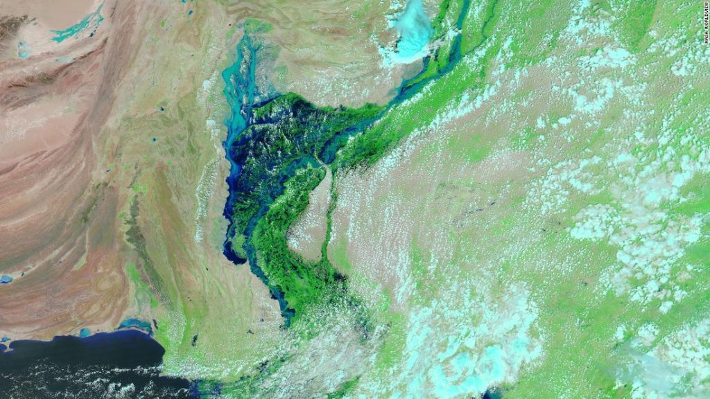
New images, taken Aug. 28 from NASA’s MODIS satellite sensor, show how torrential rains and the overflowing Indus River flooded most of the province of Indus in the south.
In the center of the image, a large area of dark blue shows the Indus River overflowing and inundating an area about 100 kilometers (62 miles) wide, turning what was once an agricultural field into a giant inland lake.
It’s a shocking departure from an image taken by the same satellite on the same date last year, which shows the river and its tributaries at what appears to be in comparison to small, narrow ranges, highlighting the extent of damage in one of the country. The worst affected areas.
According to the Pakistan Meteorological Department, this year the monsoon is already the wettest in the country since records began in 1961, and the season still has one month to go.
In both Sindh and Balochistan, rainfall was 500% above average, sweeping through entire villages and farmlands, destroying buildings and wiping out crops.
And while mostly dry weather is expected in the area in the coming days, experts say it will take days for the waters to recede.
‘Flood of horrific proportions’
In an interview with CNN on Tuesday, Pakistani Foreign Minister Bilawal Bhutto Zardari said he had visited Sindh and witnessed first-hand how the floods displaced entire villages and towns.
“There is hardly any dry land that we can find. The scale of this tragedy…33 million people, that’s more than the population of Sri Lanka or Australia,” he said.
“While we understand that the new reality of climate change means more extreme weather, or monsoons, and more intense heat waves as we saw earlier this year, the scale of the current floods is of horrific proportions. We certainly hope that a new climate will not be a reality.”
Satellite images from Maxar Technologies from other regions of the country show how floods quickly destroyed entire villages and hundreds of green plots.
Images from Jodhpur, a locality in Punjab, show how the floods destroyed homes, replacing land with winding paths of bare land.
Pakistani Prime Minister Shahbaz Sharif arrived in northern Khyber Pakhtunkhwa province on Wednesday to inspect flood damage.
The country’s National Disaster Management Authority said the province recorded the most recent deaths after the water level rose dramatically.
On Tuesday, Sharif said the floods were “the worst in Pakistan’s history” and that international assistance was needed to deal with the scale of the devastation.
Additional reporting by CNN’s Rachel Ramirez, Angela Dewan and Jean Kamensande Brumby.


More Stories
Journalists convicted in Hong Kong sedition case
Stand News: Hong Kong journalists convicted of sedition in case critics say highlights erosion of press freedom
Shark decapitates teen off Jamaica coast